More than 350 4th-12th grade students, their teachers and parents Wednesday saw firsthand at UCF how apps, maps and drones are used in geographic information systems, an interdisciplinary field that captures, analyzes and presents geographic data in meaningful ways.
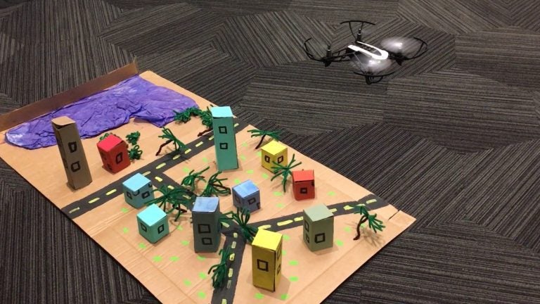
Students flew mini drones over a model town to simulate how GIS professionals fly drones over land to capture images and document pre- and post-natural disasters, changes to shorelines over time, and other views.
The event coincided with International GIS Day and the announcement that UCF’s Citizen Science GIS team – the host of Wednesday’s event – will take this immersive learning experience to Central Florida classrooms for free.
“Field trips are tough. Being able to take the citizen science show on the road is what it’s all about,” said Timothy Hawthorne, UCF assistant professor of GIS who leads the Citizen Science GIS group.
The classroom visit of the Citizen Science GIS group is called the Maps, Apps, and Drones Tour, and will be part of an educational outreach component of two National Science Foundation research grants of which Hawthorne is a part.
Teachers of local school districts and home-schooled students interested in the opportunity can visit citizensciencegis.org/tour to learn more and sign up.
Students on Wednesday also used online mapping tools to map out sustainable features of their school campuses. They saw a pre-existing web map – provided by international GIS company Esri – of migration data of the world, and discussed how such data opens doors for explorations on what the rate of migration means for the stability of a country, for instance. Activities using drones, online mapping and more are part of the learning experience Citizen Science GIS takes to classrooms.
Mount Dora Christian Academy teacher Laurel Steele, who attended Wednesday’s field trip, said she would welcome Citizen Science GIS’ immersive teaching lessons in her classroom because it showcases an up-and-coming job market to her students and the activities encourage teamwork.
Drones, online mapping and other GIS tools are used in various disciplines, such as sociology to chart movements of a culture, transportation to identify the best routes for emergencies, and real estate to identify viable and vacant land for development.
“As a public scholar and a parent, I see these technologies that are in demand but they’re not at the forefront of schools,” Hawthorne said. “Kids get so excited about this, so we want to foster that excitement further and to make UCF the school of choice for GIS.”
Beyond classroom visits, Hawthorne hopes to soon have a Geo Bus that expands the team’s ability to take this technology straight to the students at their schools. Hawthorne envisions a “mobile educational lab” with interactive stations of maps, images captured by drones, and more. He’s looking for grants and community donations to launch the Geo Bus.
“We want to provide a fun environment for the kids, and to be able to step back and let them use the technology,” Hawthorne said. “For me, it’s about connecting a practical use with this awesome technology.”